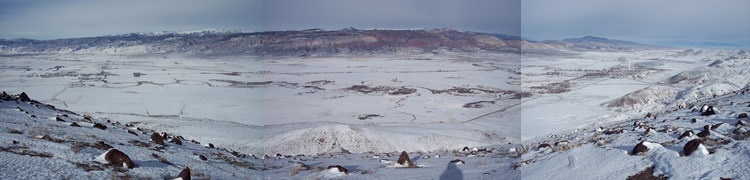
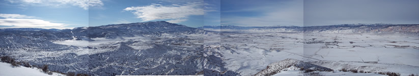
Venice North Panorama
| Home | Clinics | ||||||
|---|---|---|---|---|---|---|---|
| Central Utah Air Sports Association --- contact us | |||||||
Updated 1/29/22
Site guide
Venice Launch
Recommended Winds: North launch
PG: min 1, ideal 6, max 12 gust 3
Ideal direction 345-40 degrees, Acceptable 300-60 degrees
Min GR: 2.4
Recommended Winds: South launch
PG: min 1, ideal 6, max 12 gust 3
Ideal direction 160-220 degrees, Acceptable 135-225 degrees
Min GR: 2.4
Recommended Winds: East launch
PG: min 1, ideal 6, max 12 gust 3
Ideal direction 60-120 degrees, Acceptable 45-135degrees
Min GR: 2.4
Recommended Winds: West launch
PG: min 0, ideal 6, max 12 gust 3
Ideal direction 260-320 degrees, Acceptable 225-325 degrees
Min GR: 2.4
Recommended Ratings
North Launch P2
West launch, P2
East Launch P3
South launch P2
| Click on thumbnails to see pictures | ||
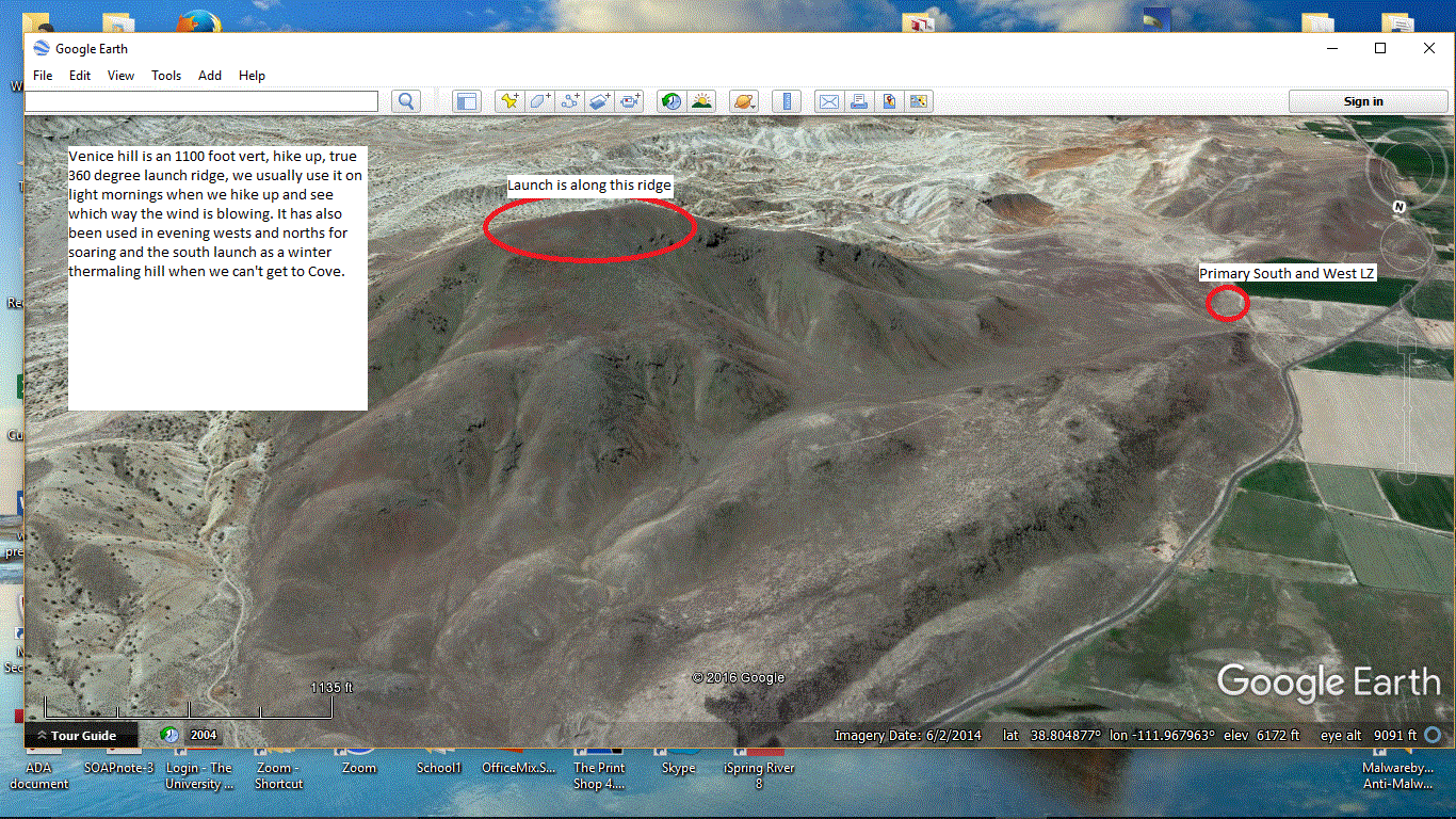
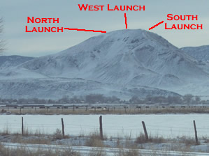 Venice Launch is an excellent 360 degree launch that can be used year round. |
A. Starting in Richfield, go East on 300 North and keep going straight on to Hwy 119 instead of curving around with old highway 89. B. Just before the Hill on the opposite side of the valley from Richfield, there is a sign that reads 'Black Knoll Rd.' That is the road to the LZ. Black Knoll Rd. follows the base of Venice hill. C. At the top of the dougway there is a small valley that will open up. Be prepared to turn left because it might sneak up on you. D. After you turn off Hwy 119, follow the dirt road for about 2 miles. The launch will become visible on the left. E. Wait until you get to the telephone poles to turn toward Venice hill. If you make the telephone pole turn, it is really hard to get lost from there. F. When you get to the bottom of the hill, you can either throw it in 4wd and see if you can make it to the rock field halfway up, or hike the 1100 feet to the top. There is not a road all the way to the top, so that is the only down side of flying Venice. |
|---|
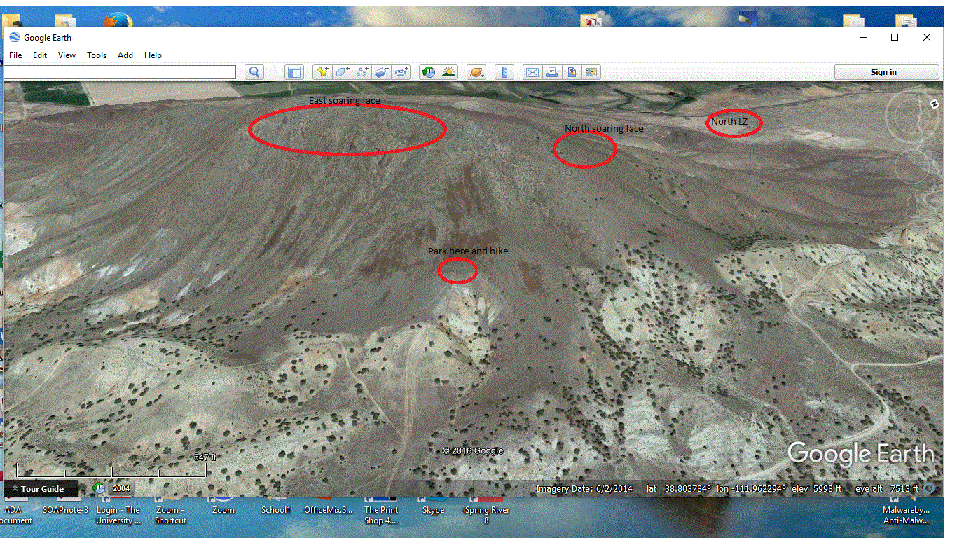
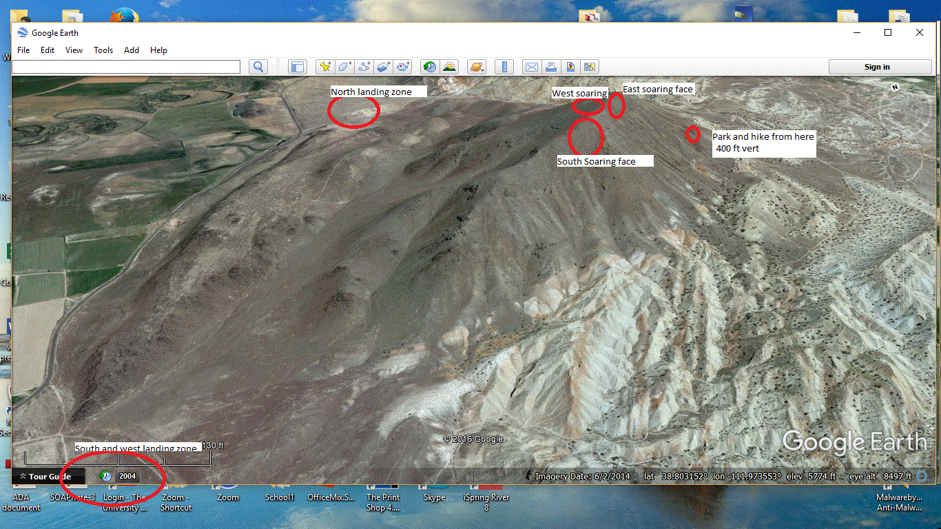
Venice Hill near Richfield Utah Launch: 6410ft/1954m GPS 38 48' 15"N 111 58'01”W LZ: 5285ft/1611m GPS 38 48' 01" N 111 58'56”W Short hike (400ft vert) - but a true 360 degree launch. Soarable on 5 different soaring faces.(Probably 6. I have never soared the NE direction although there is a good soaring face)
Venice hill has an 1100 foot vertical drop and is located 2 miles east of Venice Utah. It is a hike up site, but you can drive in from the east side and get within 400 vertical feet of launch.
Launching is possible in all directions. The North, Northwest, West Southwest and South launches require P2 skills in laminar morning and evening airflows. The East launches require P3 skills as you have limited landing options or must fly to a landing zone you can’t see from launch. Afternoon directions work best with a N, NW, W, SW, W direction. P3, P4 launching only for thermic conditions depending on honest skill level.
Mid-day launching requires P4 skills as thermals can come up from 3 different sides. Winter mid-day thermaling can be very consistent when the east and west sides are covered with snow, but the south side has melted off.
Launches are located at the top of the hill and caution should be used to avoid being blown over the back. The hill is mostly grass covered so side hill launches lower on the hill are possible and recommended in stronger conditions.
Site Features and Weather
Katabatic wind in the morning often creates a South to Southwest wind on launch.
Afternoons and evenings tend to be more West, shifting to the North, especially in the summer.
Prefrontal conditions can cause strong Southwest and South winds and can blow out the site.
Known Accidents at Venice Hill:
None
Land owner situation and insurance:
Venice hill launch and landing zones are on public and private land and are NOT insured or managed by the Central Utah Air Sports Association. (CUASA) . The information about using Venice Hill for launching and landing paragliders is provided as a free public service in order to help you fly safely and not upset the land owners and cause permission to use this site to be revoked. If you fly here you do so at your own risk and judgement. Just remember that everything you do reflects and effects all of us in the sport of free flight. If you would like advice on safely using the Venice Hill site you may contact stacy@cuasa.com - jef@cuasa.com jonathan@cuasa.com
Venice Hill site cautions:
1) P2 skills for morning and evening. Launch is possible in NE, N, NNW, NW, W, SW, SSW, S conditions.
2) P3+ skills needed for East launches and stronger conditions.
3) P4 and very advanced skills are required to attempt top landing,
4) Helmets are recommended and should be worn any time you are attached to the glider.
5) Spectators should remain 50 feet away from laid out paragliders, and be aware of launching and flying pilots.
6) Mini wings may use the Venice Hill launches, but extreme caution should be used because all of the preceding cautions are magnified when using mini wings.
7) Please keep vehicles on existing roads.
8) Stay well clear of the power lines and barb wire fencing.
9) Do not fly in rotor zones behind the ridge.
10) Katabatic wind influence is possible late evening and would come from the NE, East and SE.
11) Be aware of Virga or clouds dropping out in any of the mountain ranges surrounding.
12) The valley floor nearby is a strong thermal producer and caution should be taken when landing midday or in thermic conditions.
13) Launch is at the top of the hill and caution should be used to avoid being blown over the back. The hill on the north and west sides is mostly grass covered so side hill launches lower on the hill are possible and recommended in stronger conditions.
This looks like the inspiration for some poem, don't you think?
Venice South Pan
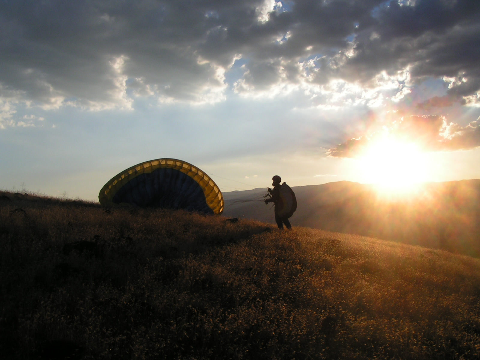
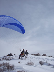
Picture 1: Dave on South Launch with reverse inflation and assistance from instructor Stacy
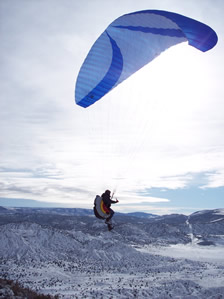
Picture 2: Dave getting into his seat after launch
Venice West Pan