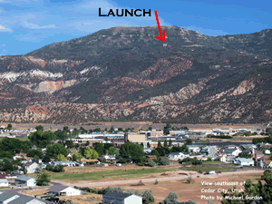
Cedar 'C' is one of the three Utah launches with a paved road to launch. (these directions are on the dirt road though)
![]() A:
A:
![]() B:
B:
![]() C:
C:
![]() D:
D:
![]() E:
E:
![]() F:
F:
![]() G:
G:
B. This is the intersection at Main. From here go East and the road will curve South.
C. The first left should be Greens Lake Drive.
D. Follow Greens Lake Drive toward the mountain and you should see a water tank. You will drive up the hill past the water tank and keep going for a few miles.
E. When you are getting close, you will notice the radio towers. Launch is just below them.
F. You can take two turnoffs to reach launch. The first is High Cedar Highlands Drive. This is the sign - turn left.
G. If you miss that turn, go to the next turnoff and go left (it is a fork, so you have to turn) until you meet up with High Cedar Highlands Drive again. Go to the next stop sign and launch is directly to the left.